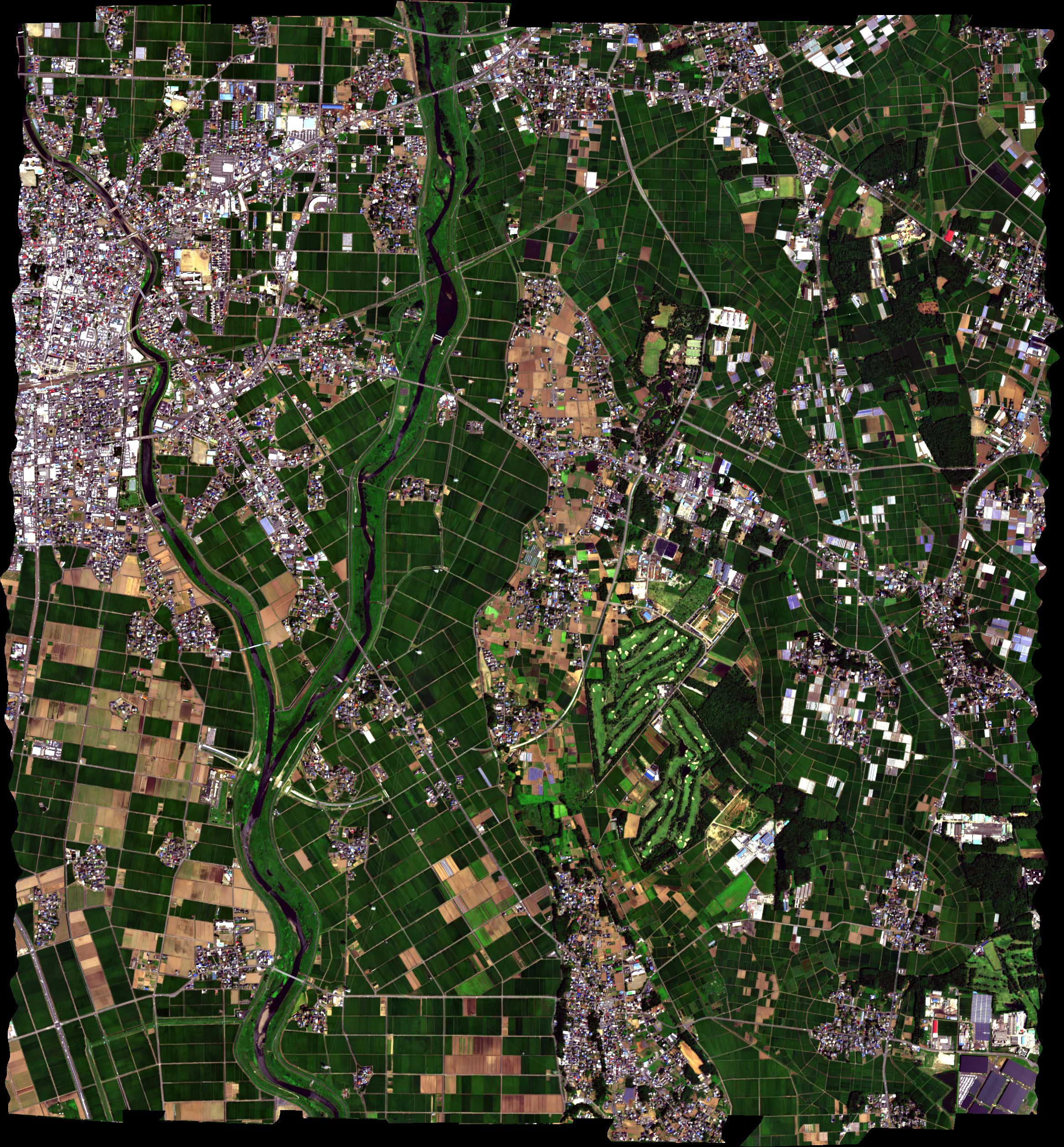
The airborne hyperspectral dataset was taken by Headwall Hyperspec-VNIR-C imaging sensor over agricultural and urban areas in Chikusei, Ibaraki, Japan, on July 29, 2014 between the times 9:56 to 10:53 UTC+9. The central point of the scene is located at coordinates: 36.294946N, 140.008380E. The hyperspectral dataset has 128 bands in the spectral range from 363 nm to 1018 nm. The scene consists of 2517x2335 pixels and the ground sampling distance was 2.5 m. Ground truth of 19 classes was collected via a field survey and visual inspection using high-resolution color images obtained by Canon EOS 5D Mark II together with the hyperspectral data. The hyperspectral data and ground truth were made available to the scientific community in the ENVI and MATLAB formats at http://park.itc.u-tokyo.ac.jp/sal/hyperdata. More details of the experiment are presented in the technical report given below.
In order to use the datasets, please fulfill the following three requirements:
1) Giving an acknowledgement as follows:
The authors gratefully acknowledge Space Application Laboratory, Department of Advanced Interdisciplinary Studies, the University of Tokyo for providing the hyperspectral data.
2) Using the following license for hyperspectral data:
http://creativecommons.org/licenses/by/3.0/
3) This dataset was made public by Dr. Naoto Yokoya and Prof. Akira Iwasaki from the University of Tokyo. Please cite:
In WORD:
N. Yokoya and A. Iwasaki, "Airborne hyperspectral data over Chikusei," Space Appl. Lab., Univ. Tokyo, Japan, Tech. Rep. SAL-2016-05-27, May 2016.
In LaTex:
@techreport{NYokoya2016,
author = {N. Yokoya and A. Iwasaki},
title = {Airborne hyperspectral data over Chikusei},
institution = {Space Application Laboratory, University of Tokyo},
number = {SAL-2016-05-27},
address = {Japan},
month = {May},
year = 2016,
}
What is it?
-----------
CNMF is an algorithm to fuse hyperspectral data with either multispectral or panchromatic data to obtain high-resolution hyperspectral data. This set of MATLAB or Python codes implements the methods described in
[1] N. Yokoya, T. Yairi, and A. Iwasaki, "Coupled nonnegative matrix
factorization unmixing for hyperspectral and multispectral data fusion,"
IEEE Trans. Geosci. Remote Sens., vol. 50, no. 2, pp. 528-537, 2012.
[2] N. Yokoya, N. Mayumi, and A. Iwasaki, "Cross-calibration for data fusion
of EO-1/Hyperion and Terra/ASTER," IEEE J. Sel. Topics Appl. Earth Observ.
Remote Sens., vol. 6, no. 2, pp. 419-426, 2013.
[3] N. Yokoya, T. Yairi, and A. Iwasaki, "Hyperspectral, multispectral,
and panchromatic data fusion based on non-negative matrix factorization,"
Proc. WHISPERS, Lisbon, Portugal, Jun. 6-9, 2011.
See the file LICENSE for copying conditions.
Please kindly report any suggestions or corrections to naoto.yokoya@riken.jp
Release date
------------
April 11, 2016
How to use it?
--------------
The MATLAB version includes three folders:
'Demo': a demo program of CNMF using synthetic data.
'CNMF': the CNMF source code.
'Quality_Indices': source codes for quality indices.
The Python version includes two Python files:
'Demo_CNMF': a demo program of CNMF using synthetic data.
'CNMF': the CNMF source code.
System-specific notes
---------------------
The MATLAB version was tested using MATLAB R2015b on Windows 7 machines.
This Python version was tested using Python 2.7.5 on Windows 7/8 machines and Python 2.7.3 on a Mac OS X 10.9.5 machine.
Licensing
---------
Copyright (C) 2016 Naoto Yokoya
This program is free software: you can redistribute it and/or modify
it under the terms of the GNU General Public License as published by
the Free Software Foundation, version 3 of the License.
This program is distributed in the hope that it will be useful,
but WITHOUT ANY WARRANTY; without even the implied warranty of
MERCHANTABILITY or FITNESS FOR A PARTICULAR PURPOSE. See the
GNU General Public License for more details.
You should have received a copy of the GNU General Public License
along with this program. If not, see
Contact Information:
--------------------
Naoto Yokoya: naoto.yokoya@riken.jp
Naoto Yokoya is with the Geoinformatics Unit, the RIKEN Center for Advanced Intelligence Project (AIP), RIKEN, Japan.